This Hurricane season, Hurricane Erin 2025 has spun back up to a Category 4 storm.
According to the National Hurricane Center, Erin is packing sustained winds around 130 mph. That’s strong enough to rip roofs off homes and flood coastal roads if the system edges closer. Hurricane Erin may still be northeast of the Bahamas, inching northwest at about 12 mph, but its reach is wide. Swells and rough surf are already reached beaches from Florida to the Carolinas. On the Outer Banks of North Carolina, the danger feels especially close.
Heavy rain battered Puerto Rico on Sunday. Turks and Caicos and the eastern Bahamas, including San Salvador Island, could see up to 6 inches of rain through Tuesday, forecasters said. Flash flooding, landslides or mudslides are possible. Hatteras Island is under a mandatory evacuation order, and for good reason: N.C. Highway 12 the lone road connecting much of the island could go under water once tides climb.

Anyone who decides to “ride it out” might find themselves cut off, with no way in or out.
If you walk along the beaches today, you can already see the signs
Strong rip currents, foamy waves breaking hard, and sand being pushed inland. Forecast models suggest this isn’t letting up anytime soon. Flooding tides, erosion, and beach over wash are expected to begin Tuesday and stretch into Thursday.
What is Hurricane Erin Eyewall Replacement Cycle?
Rough ocean conditions will likely cause life-threatening surf and rip currents, the NHC said.
The Bahamas, which provides some meteorological services for the Turks and Caicos Islands, issued a Tropical Storm Watch for the British islands to its southeast.
Erin has also raised concerns about wildfire risks if human-caused sparks ignite parched vegetation and strong dry winds fan the flames. BMS Group Senior Meteorologist Andrew Siffert said these conditions could arise if Erin grows into a powerful offshore storm fueled by colliding warm and cold air rather than tropical seas.
medics, are bracing for calls they hope won’t come. The blunt warning from county leaders once the storm surge pushes through, responders may not be able to reach you.
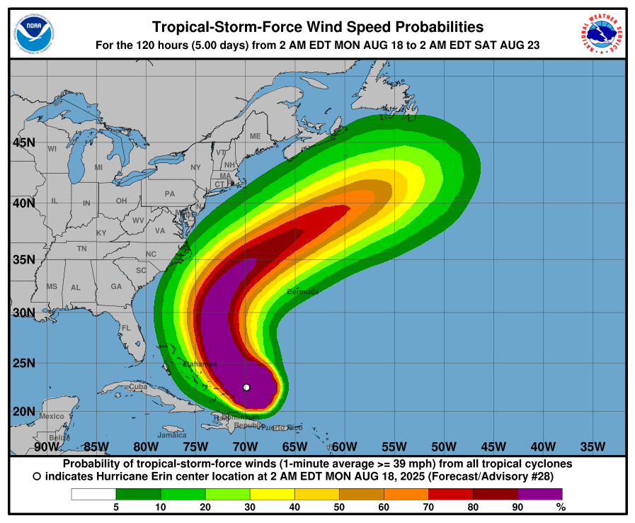
Right now, Erin sits just northeast of the Bahamas, and while models show it curving northward before hitting the U.S. directly,
The Outer Banks and Mid Atlantic will still feel plenty of impact. Hurricane Erin force winds stretch out 60 miles from the center, while tropical storm force winds reach nearly 230 miles. That means coastal Virginia, Maryland, and even New Jersey are looking at elevated tides and dangerous surf by midweek. The Erin hurricane tracker from NOAA shows the storm bending out to sea, but meteorologists keep repeating the same phrase. “Do not focus on the center.” Its outer bands are wide enough to spread problems well beyond North Carolina.
Latest updates from NOAA
Forecasters admit they’re keeping a nervous eye on Erin’s behavior. Just last week it was Category 5 strength before its weakening, only to strengthen again over warm Atlantic waters. That kind of back and forth makes the storm unpredictable, and for barrier islands already vulnerable to erosion, unpredictability is the last thing anyone wants.
Why hurricane Erin is different than the other hurricane
Erin’s restrengthening is a reminder that one storm can upend everything, especially for communities perched on thin strips of sand like the Outer Banks. Even if Erin never makes landfall, the flooding tides, crashing surf, and widespread rip currents will affect thousands of people along the East Coast. Local officials and the National Hurricane Center are saying the same thing. “keep watching the hurricane Erin path map, pay attention to local weather alerts, and if the word comes down to evacuate, don’t wait until you see the water rising at your doorstep”
or more updates stay tune to our website


